Two feet.
Two feet was the difference on Friday afternoon between failure and success, and the effort to find English Cave succeeded. For the first time in 100 years, contact was made with one of the most mysterious and inaccessible historic beer caves in St. Louis. And to think, if the drilling derrick used to make that first contact had only been two feet to the west, it would have missed the void in the limestone bedrock completely.
A lot has been happening since I first wrote about the effort to save the English Cave Community Garden and the long-lost cavern deep under the surface of the Benton Park neighborhood. The house of Bill Kranz’s girlfriend, Marian Amies, just to the west of the garden, became the unofficial headquarters of the English Cave Steering Committee, the organized effort to rediscover English Cave. The Benton Park Neighborhood Association was able to acquire the property along Provenchere Place, thus preserving the land for the community garden. Fundraising began for drilling two holes in the garden with the purpose of hitting the cave, which the English Cave Steering Committee referred to as the “Void.” Donations were provided by the Missouri Speleological Survey, Benton Park Neighborhood Association, Meramec Valley Grotto, and many others. Drilling was first delayed back in January, but, finally, on Thursday, the drilling, provided by Geotechnology, Inc., began work on the first hole, originally intended to be around four inches in diameter.
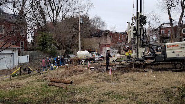
After passing through approximately 16 feet of soil, the drill hit limestone bedrock. Continuing into the rock, drilling was going well until a layer of sand stopped drilling for the day when the bit became stuck. The suspense was high overnight, but the next day, on Friday, the drilling continued, this time switching to a smaller hole of around two inches. Just after lunch, the drill broke through into the Void—English Cave. For the first time in a century, the outside world had made contact with the historic lagering cave, with only two feet to spare to the west before they would have hit the wall and missed entirely. Joe Light, president of the Meramec Valley Grotto, a caving group who had donated $500 to the drilling effort, summarized the importance of this cave in the context of St. Louis brewing and speleological history:
“This is the Area 51 of the St. Louis caving scene,” speaking of English Cave out of the 38 total caverns known in the City of St. Louis, “This is the grand mystery.”
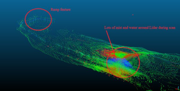
The curtain began to be pulled back when Dr. Kenneth Boyko, a post-doctoral fellow in geological engineering at the Missouri University of Science and Technology, began to take LIDAR measurements of the cave, after the delicate laser measuring instrument tool had been threaded like a needle down the 49-foot bore hole. LIDAR works by “firing” millions of laser beams in horizontal and vertical orientations, and measures how long it takes for the light from the laser to bounce back to the LIDAR instrument. Dr. Boyko explained that LIDAR is incredibly reliable, as the laser beams can travel great distances, and since we know the speed of light, we can calculate how far away an object or wall is by how long it takes for the laser to bounce back to the LIDAR instrument. But there are a few issues. Some surfaces can still cause the laser to bounce off, particularly aluminum. Also, because water can slow down the speed of light compared to air, it can result in some slightly inaccurate readings, but for the purposes of measuring the cave, this was not a significant issue. Dripping water can also create “static” when the laser beams hit water drops coming off the ceiling of the cave.
As the LIDAR began to acquire 10 million data points in its first scan (later scans had over 40 million), a virtual image of English Cave began to emerge on Dr. Boyko’s computer screen on the surface. Popular conceptions of the famous cave were both confirmed and refuted.
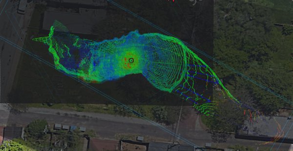
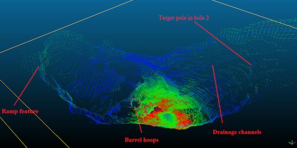
First, English Cave was in fact as deep as newspaper articles from the 19th century said it was, and just as contemporary sources had claimed, is very large. It stretches like a giant letter “S” much like an underground river, deep in dissolved limestone in what is known as karst topography, the porous, cavern-and-sinkhole-pockmarked topography under South St. Louis. Of particular interest, the LIDAR picked up the shape of a cylindrical object, which was later confirmed to be a deteriorated, collapsed barrel, and revealed two parallel drainage channels that were cut into the rock floor. There were also bricks lying scattered on the floor.
It was obvious, even from more than 50 feet above on the surface, that this cave had been altered by human hands. But the image of a giant labyrinth, with passages snaking off in every different direction, including under the lake in Benton Park, is almost certainly now a myth. As evening fell, the team dropped a GoPro down the hole, neighbors began to congregate, and 9th Ward Alderman Dan Guenther, who had helped grease the wheels for this to happen in his ward, stopped by to survey the scene, and we spoke briefly. “I appreciate the passion of Bill and Marian and all the other supporters in the neighborhood who have made the drilling possible and have finally shed light on the infamous English Cave,” he said.
Over the weekend Dr. Boyko and other members worked to ascertain the location to drill the second hole, and drilling began on Monday morning. It quickly broke through, and LIDAR scanning began again in the afternoon. This hole, further away from obstructions, provided a much more open view of the cave, and revealed that the void continued in both directions much further than we realized on Friday evening. In fact, in one direction, the LIDAR was not able to see far enough to determine where the cave ended. In the other direction, however, the laser picked up a tantalizing piece of evidence: the outline of a doorway and a ramp or staircase going up. Wherever that staircase goes, it is no longer accessible from the surface. For Kranz, the next step involves getting better images of the cave.
“The future is getting a robot down there to get closer video of all that remains down there,” Kranz explains, “so we can make a 3Dmodel so everybody can enjoy it in virtual reality.”
And that brings me to an important “public service announcement.” While the cave was accessed through drill holes in the community garden, portions of the cave are under private property. The last thing anyone involved wants is the general public trespassing on neighbors’ property or otherwise bothering residents of the Benton Park neighborhood. There is no way to access English Cave by trespassing on private property or by engaging in any other illegal acts. In the future, the hope is to open a small, legal passage that would allow rappelling access from the surface. Light has experience with such an access system devised for Carroll Cave in Camden County.
“We’ve entered a new realm with English Cave,” Kranz concludes. We’re going to start publicizing our discovery and I think they’d be really thrilled to hear what we’ve accomplished out here the last couple days. It was a huge effort; the English Cave Steering Committee has 32 names on it.”
Kranz also reminisces back to Washington University Professor John Hoal’s musing on English Cave: “No one has been able to crack the code.”
Kranz triumphantly observed, “So we did.”