When Richard Compton and Camille Dry chose the first plate of their famous Pictorial St. Louis, they didn’t pick the bustling Levee District, the center of commerce, or Lucas Place, the exclusive residential enclave. Instead, when it was time to sell their idea of making a giant panoramic aerial view of St. Louis, they chose the Near North Riverfront, that area north of Laclede’s Landing that once served as an emblematic cross-section of the Gateway City, where the Mississippi River, industry, commerce, and teeming residential neighborhoods collided. Here, the lithographer could show off his skill at rendering towering smokestacks, huge grain elevators, riverboats, and rocky bluffs at the same time.
Today, everything in what ended up as Plate No. 19 in the larger work of Pictorial St. Louis, published in 1876, is almost gone. I thought about that recently as I walked around the area that is now north of the Martin Luther King Bridge, and looked up at the giant, hulking (and empty) masses of the old refrigerated warehouses designed by Isaac Taylor and his competitors. It’s been almost six years now since I last wrote about this area, and at the time I was bemoaning the possible destruction of all these historic buildings for a new football stadium. While I had a sneaking suspicion that I didn’t really need to worry about the stadium destroying anything, I was intrigued by a completely forgotten part of the city that had been “rediscovered.”
The Near North Riverfront has firmly returned to being forgotten except to a small section of the St. Louis region. How does a place as depicted in Pictorial St. Louis in 1876 with a possible population of thousands go to a residential presence of perhaps a few dozen? It’s located right by an interstate highway with connections to the rest of the region and employment. It has views of the river. There are also amazing rail connections if industry is looking to move in. Why are so many acres of this seemingly prime real estate still sitting empty after a half-century or more of abandonment? The first 100 years looked like they went so well.
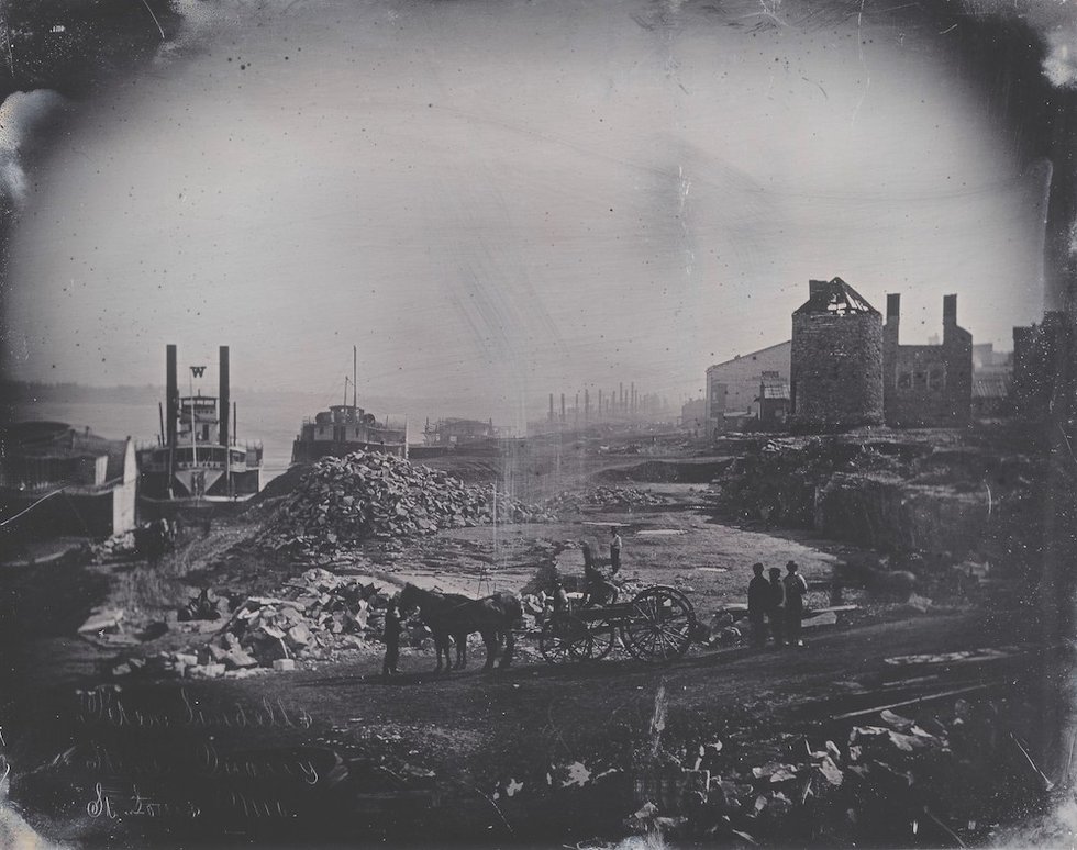
The land itself has a rich pedigree; at the far north end of the original grid of the town of St. Louis, there was even an old tower left for the Spanish defenses, known as Roy’s Mill. Title research reveals that the land was originally owned by former mayor Brian Mullanphy (whose several-hundred-page will was filed with the Recorder of Deeds when he died at the age of 42) and Peter Lindell, who owned property throughout the city, including a quarry by the river in the neighborhood. Lindell’s house was originally located nearby, at Third and Lucas streets. Wiggin’s Ferry, which was a critical connection to the Illinois side of the river, also departed nearby. Because of that link, extensive rail connections—that would expand eventually to destroy much of the historic fabric of the Near North Riverfront—would develop in the area. That’s why a train tunnel still cuts through the Arch grounds to this day.
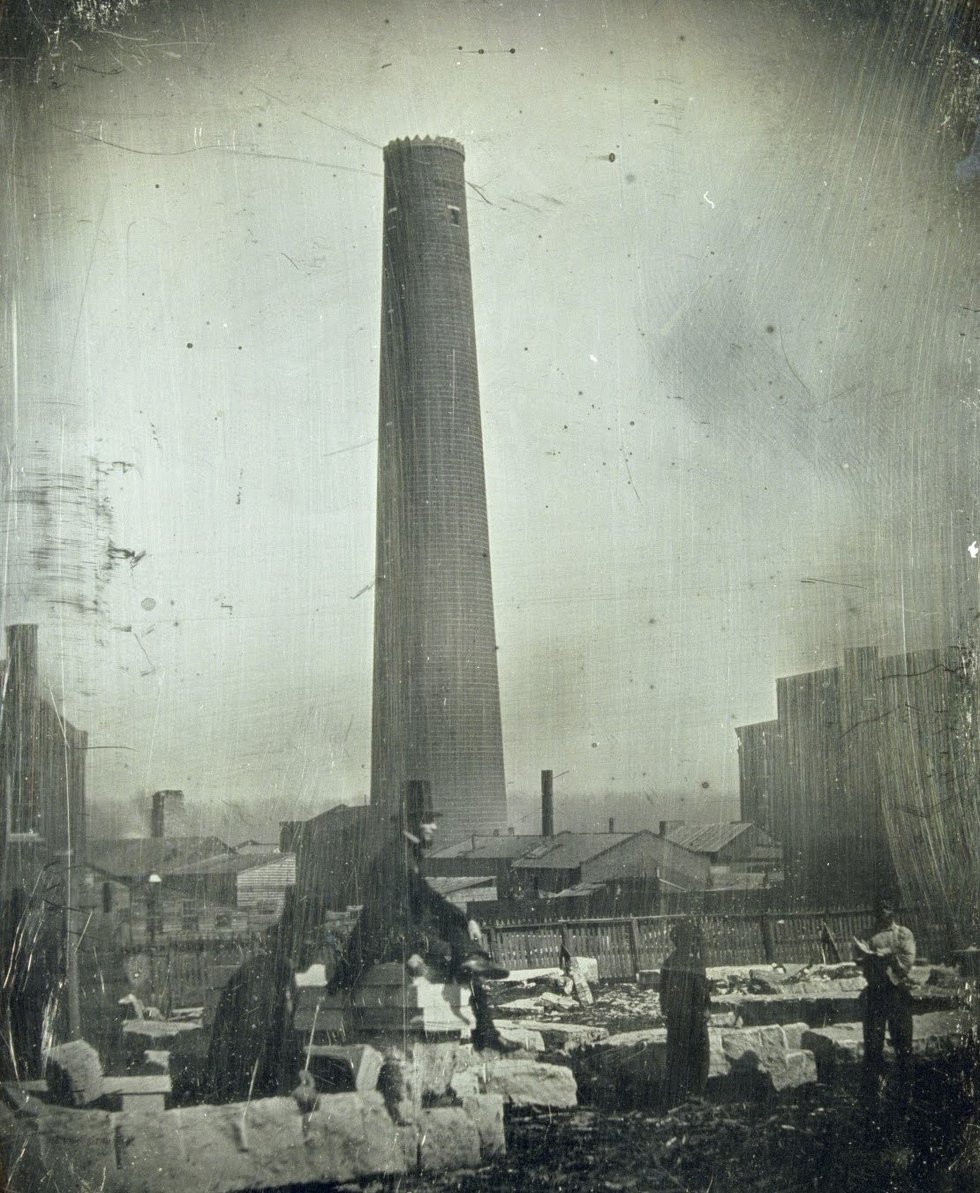
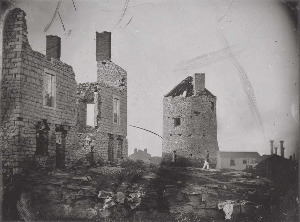
Perhaps one of the most unique industrial structures swept away by later development was Shot Tower, owned by Luther Kennett. One of many such towers across America, Shot Tower used gravity to produce spherical lead bullets, or “shot,” in a simple but ingenious way. Dropping molten lead through circular holes high at the top of the tower, the drops of metal would fall, attaining zero gravity, and forming perfect spheres, hardening before hitting the bottom of the tower. As was typical, Kennett’s Shot Tower was crowned with crenellations to give it the appearance of a castle turret. It was in ruins by the early 20th century and was replaced by the Cotton Belt Depot.
Nearby, one of the grandest sugar refineries in America once called the Near North Riverfront home as well.
I’m not expecting a new quarry, Shot Tower, or sugar refinery to spring up in the next couple of years. But rather, I hope St. Louisans wonder why so much land sits unused and fallow, and why such beautiful buildings are sitting empty, waiting for someone to use them again. Thankfully, Artica will be back again this year, Al’s Restaurant is still there, and earlier in May, New Music Circle hosted a concert by STL String Collective, who performed in the field surrounded by some of those iconic buildings.
I took a walk around the area last Saturday with two friends, looking up at the buildings, and trading stories of art exhibits or performances we’ve enjoyed in the spaces between the flood wall and the Cotton Belt Freight Depot. We’ve witnessed how the blank canvas of this open, vacant land has produced so much creativity, even in the midst of so much desolation. I can only imagine the possibilities if more people returned to the Near North Riverfront permanently.